Professional Observation
Basic Information
Observation Details
Observation Date:
March 22, 2023 - March 22, 2023Submitted:
March 22, 2023Observer:
Clancy Nelson and Steve Mace | ESAC ForecasterZone or Region:
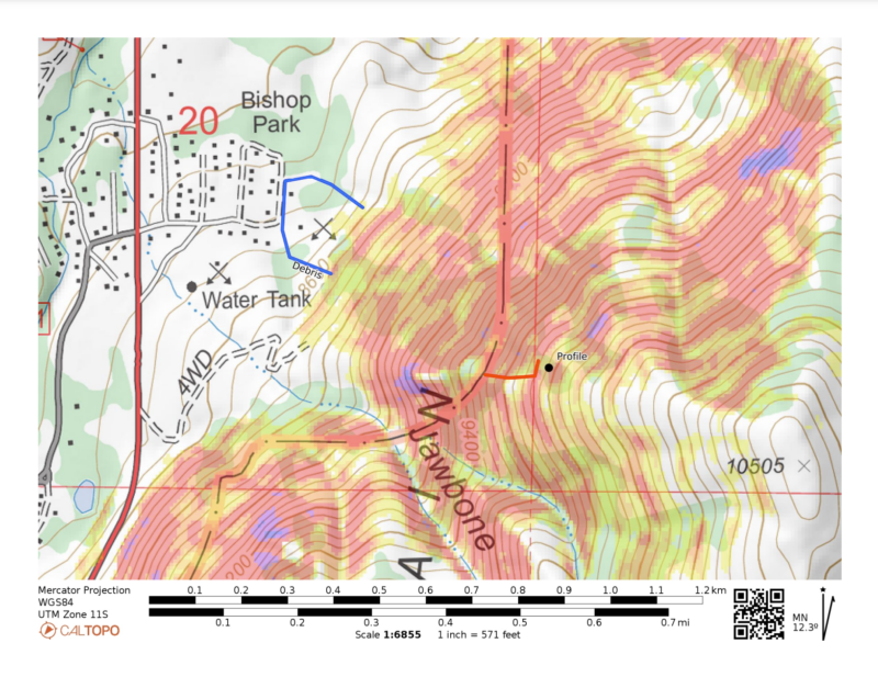
Bishop CreekLocation:
Aspendell Avalanche - Final ReportSigns of Unstable Snow
Recent Avalanches?
None ObservedCracking?
None ExperiencedCollapsing?
None ExperiencedKey Points
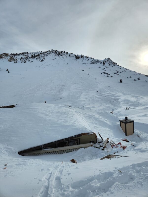
Aspendell Avalanche
2 unoccupied buildings damaged
1 unoccupied building destroyed
Eastern Sierra Nevada, Table Mountain, Aspendell, CA
Inyo National Forest – January 10, 2023
SYNOPSIS
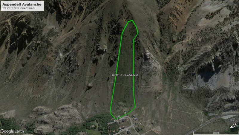
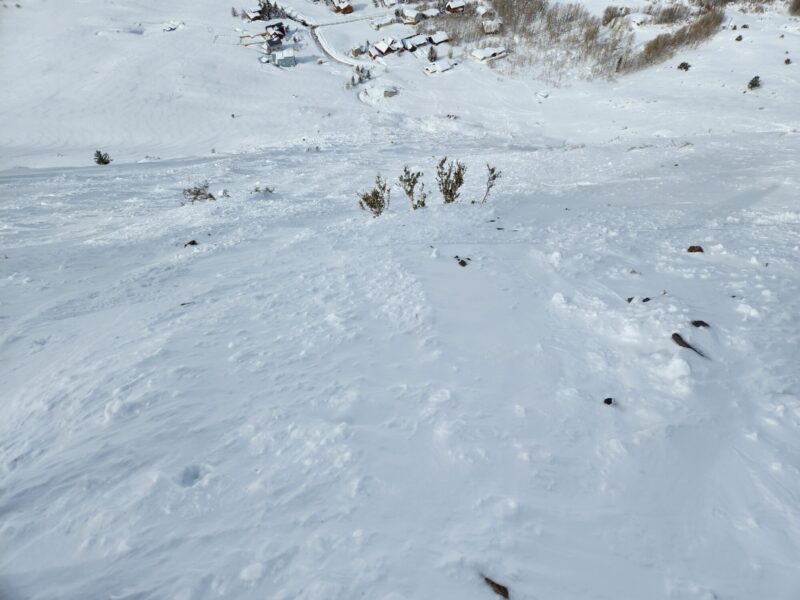
At 0925 on Tuesday, January 10, during an Atmospheric River (AR) event a natural avalanche destroyed 1 and damaged 2 other unoccupied buildings in the town of Aspendell, CA. The avalanche broke when hard, wind-deposited snow failed and stepped down to persistent grains near the ground. The slope was 42° in steepness at the start zone. The crown was 6 to 8 feet deep and 443 feet wide. The vertical fall was 1250 feet. The debris covered historic mining equipment and damaged 2 homes on Alpine Drive. A 3rd house was completely destroyed. All buildings were unoccupied with no injuries reported. The avalanche is classified HS-N-D3-R4-O.
GPS coordinates and elevation:
Toe of debris: 37.23824, -118.59352 (8,454’)
Crown: 37.23444, -118.58742 (9,706’)
WEATHER
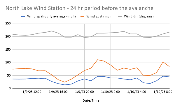
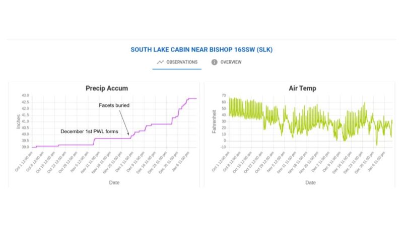
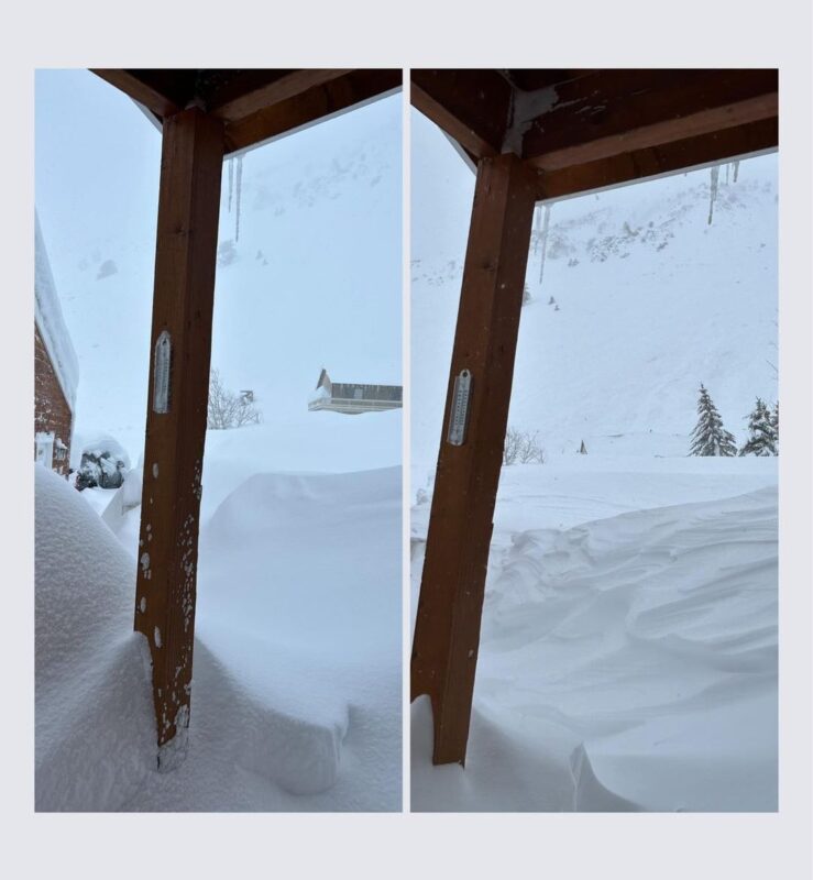
Weather data was collected from the South Lake (SLK) Weather Station (9,600’) and a wind station (10,500’) on the ridge of nearby Bishop Bowl above North Lake. The weather stations are approximately 4 miles southeast and 1.5 miles west of Aspendell respectively. Tuesday, January 10th was the 3rd day of a prolonged storm event. There was heavy snowfall and it was windy. The storm total (HST) around the time of the avalanche (0900) was 55” and the accumulated water for the storm was 5.4”. 4.56” of that water total fell in the preceding 24 hours (HN24W). Winds were blowing at an average of 34 mph from the southwest (209°) with a max gust of 111 mph. Temperatures fell during the same 24-hour period from 30°F to 22°F.
SNOWPACK
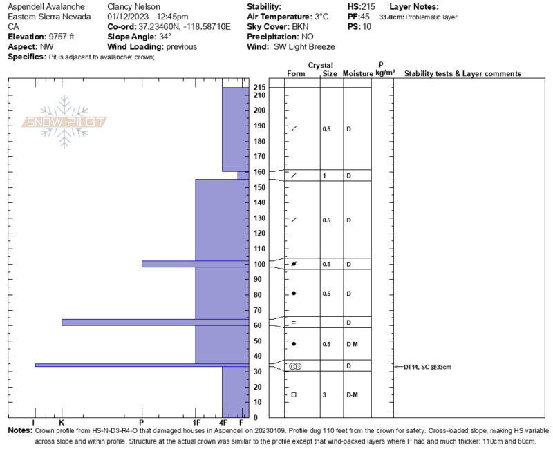
The avalanche occurred at 9,706’ on a northwest aspect (298°, measured) of Table Mountain. The slope angle at the crown was measured as 42° and the slope angle for the overall path averaged 38°. The start zone was cross-loaded by the wind and the crown ran up the looker’s right side of the slope before crossing the top of the slope. We measured the crown 6’ deep on the right side where the snowpack consisted of dense layers of wind-packed and new snow over old facets above the ground. The snowpack overlying the facets in our crown profile was 8’ deep with a similar structure. There were hard rain (K, IFrc) and melt-freeze (I, MFcr) crusts in the slab.
Snowfall that accumulated between mid-October and November 10th (9” snow and 0.7” SWE) faceted during a prolonged period of dry and cold weather that stretched from November 11th through November 30th. The overlying hard slab (4F to P hardness) developed during alternating cold and warm storms between December 1st and 15th and during a series of warm, wet AR events between December 26th and January 10th. The AR that culminated in the avalanche began on January 8th. 5.4” of snow water equivalent (SWE) loaded the snowpack in that time raising the avalanche danger from CONSIDERABLE to HIGH on the day of the event.
Avalanche Advisory: https://www.esavalanche.org/forecasts/#/forecast/1/116854
INVESTIGATION
The event was initially reported by local residents in observations on the Eastern Sierra Avalanche Center (ESAC) website and on the ESAC Instagram feed. The onsite investigation occurred on January 12th and was conducted by Steve Mace (ESAC Director) and Clancy Nelson (ESAC forecaster, author). The same day, Steve Mace and Clancy Nelson interviewed a neighboring resident who has since provided supporting documentation.
Questions can be directed to:
Steve Mace
Director, Eastern Sierra Avalanche Center
303-618-8231
Media